
Spotty Strong Storms Saturday With High Heat; Dry Sunday
Spotty Strong Storms Saturday With High Heat; Dry Sunday
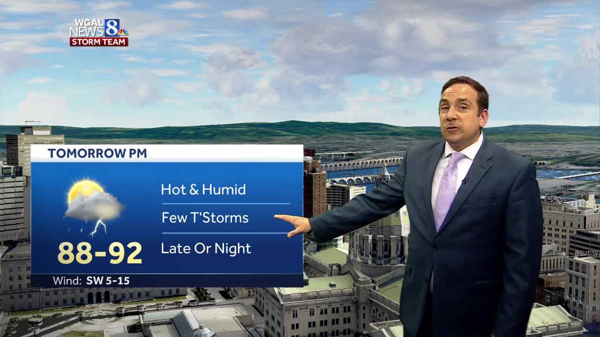
Temperatures peak near 90 degrees Saturday with chances for few showers and thunderstorms. Some storms may become strong to severe with gusty winds, heavy rain, and hail.
THAT WAS MATTY AUGUSTINE REPORTING. NOW FOR THE WGAL NEWS EIGHT STORM TEAM FORECAST WITH METEOROLOGIST ETHAN HOUSTON. IT’S GOING TO BE A SCORCHER OUT THERE THROUGH THE DAY TOMORROW. TEMPERATURES RISING BACK INTO THE 90S WHEN YOU FACTOR IN THE HUMIDITY. IT’S GOING TO FEEL LIKE IT’S IN THE MID 90S. HIGHER HEAT, HIGHER HUMIDITY. THAT’S THE FUEL FOR SOME PASSING SHOWERS AND THUNDERSTORMS. SOME OF THESE COULD BE STRONG BY ABOUT THIS TIME TOMORROW. I THINK MUCH OF THE VALLEY WILL STAY DRY THROUGH A LARGE PORTION OF OUR SATURDAY, BUT AS WE GET CLOSER TO SUNSET AND PAST SUNSET, SOME OF THESE STRONG STORMS WILL ACCOMPANY AN INCOMING COLD FRONT THAT PUSHES THROUGH AND BRINGS LESS INTENSE HEAT THROUGH THE DAY. SUNDAY OUTSIDE RIGHT NOW, STILL MOSTLY CLEAR SKIES, BUT WE’RE STARTING TO SEE SOME CLOUDS MOVE IN INTO OUR WESTERN COUNTIES AND THAT TREND WILL CONTINUE THROUGH THE NIGHT. RIGHT NOW, IT’S 71 IN HARRISBURG. DEW POINTS STILL IN THAT LOW TO MID STICKY RANGE OUT THERE. THEY’LL START TO RISE THROUGH THE NIGHT, BUT ALL IS QUIET LOCALLY ON THE RADAR. BUT AS WE LOOK OFF TO OUR WEST, WE’RE KEEPING OUR EYE ON THIS COMPLEX OF SHOWERS AND STORMS NOW MOVING INTO NORTHWESTERN PENNSYLVANIA. IT’S MOVING DUE EAST, BUT IT MAY CLIP OUR NORTHERN COUNTIES AS WE HEAD THROUGH THE NIGHT TONIGHT. MOST OF US WILL STAY DRY. BUT NOTICE THE SERIES OF AREAS OF SHOWERS AND STORMS OFF TO OUR NORTH AND TO THE WEST REALLY HAD SOME STRONG THUNDERSTORMS THAT MOVED THROUGH THIS EVENING TOWARDS MINNEAPOLIS. THAT’S WHERE WE FIND THE STORM SYSTEM THAT’S GOING TO CROSS OVER THE GREAT LAKES AND THIS COLD FRONT WILL GET CLOSER TO US BY ABOUT THIS TIME TOMORROW AND HELP TRIGGER THOSE PASSING SHOWERS AND STORMS. PARTLY CLOUDY TONIGHT, MILD A FEW ISOLATED THUNDER SHOWERS IN OUR NORTHERN COUNTIES. LOWS TONIGHT WILL BE SEASONABLE IN THE LOW EXCUSE ME, IN THE MID TO UPPER 60S. TOMORROW MORNING. LOOK FOR PARTLY SUNNY SKIES. SLIM CHANCE OF AN ISOLATED THUNDER SHOWER. IT WILL BE NOTICEABLY MORE HUMID AND THAT HUMIDITY WILL BUILD AS WE HEAD THROUGH THE AFTERNOON. LOOK FOR HIGHS TO BE UP NEAR 90 DEGREES. AND IF YOU PASSING SHOWERS AND THUNDER SHOWERS WILL BE POSSIBLE LATE IN THE EVENING ON INTO THE OVERNIGHT HOURS. AND SOME OF THOSE MAY BE STRONG POTENTIALLY BE SEVERE. BEST CHANCE FOR THE SEVERE WEATHER IS TO THE NORTH OF THE TURNPIKE ON A LEVEL OF 1 TO 5. LOOKING AT A LEVEL TWO OUT OF FIVE AREAS, SOUTHEAST OF THE TURNPIKE, A LITTLE BIT OF A LOWER THREAT. OVERALL THREAT IS LOW, BUT SOME OF THESE STORMS, BECAUSE IT IS GOING TO BE SO WARM AND HUMID, COULD REALLY GET GOING. DAMAGING WINDS, HEAVY RAIN AND LARGE HAIL NOT OUT OF THE QUESTION TOMORROW EVENING INTO TOMORROW NIGHT. MADE IT TO 86 FOR OUR HIGH TODAY AFTER MORNING LOW OF 68, PRETTY CLOSE TO AVERAGE FOR THIS TIME OF THE YEAR. WE’RE AT 71 RIGHT NOW IN THE CAPITAL CITY, 73. IF YOU’RE WATCHING US IN LANCASTER, STILL CLOSE TO 80. IN CHAMBERSBURG, YOU CAN SEE THAT WARMER AIR THAT’S OFF TO OUR SOUTH AND TO THE WEST. AND ALSO THE MORE HUMID AIR WITH TEMPERATURES. YEAH, SITTING IN THE MID 70S, UPPER 70S RIGHT NOW ACROSS THE MID MISSOURI RIVER VALLEY. THAT’S THE MORE HUMID AIR THAT’S GOING TO BE PUSHING IN ACROSS THE REGION. THANKS TO THIS DEPARTING RIDGE OF HIGH PRESSURE AS IT MOVES OFF THE EAST COAST ALONG THE OUTER BANKS. BUT THIS STORM SYSTEM IS GOING TO TREK ACROSS THE GREAT LAKES AND DRAG THAT FRONT ACROSS THE REGION AND HELP FIRE UP SOME PASSING SHOWERS AND STORMS. AGAIN, THEY’LL BE SPOTTY IN NATURE. DON’T CANCEL ANY OUTDOOR PLANS AND THEY SHOULD BE COMING IN CLOSER TO SUNSET ANYWAY. SO. SO HERE COMES THE WARM FRONT THAT MAY TRIGGER A FEW ISOLATED SHOWERS, BUT THAT PASSING DISTURBANCE OFF TO OUR WEST AS WE GET CLOSER TO DAWN AND THEN A POP UP SHOWER THUNDERSHOWER NOT OUT OF THE QUESTION DURING THE AFTERNOON, BUT DURING THE EVENING HOURS. HERE COMES THAT FRONT. SOME OF THOSE STORMS MAY BE ROBUST HEADING INTO SUNDAY. IT LOOKS LIKE IT IS GOING TO BE A DRY DAY A LITTLE BIT MORE COMFORTABLE WITH HIGH PRESSURE COMING DOWN FROM CANADA. BUT THE BREAK FROM THE HUMIDITY WILL BE BRIEF AND JUST EVER SO SUBTLE COMPARED TO SATURDAY. MORE SHOWERS AND THUNDERSTORMS WILL BE AROUND ON MONDAY. SOME OF THOSE COULD BE STRONG. MAY SEE A FEW ISOLATED SHOWERS LINGERING INTO TUESDAY. LESS HUMID WEATHER WILL BE AROUND FOR TUESDAY AND WEDNESDAY AND THEN STARTS TO WE START TO SEE THE HUMIDITY CREEP BACK UP AGAIN AS WE APPROACH
Spotty Strong Storms Saturday With High Heat; Dry Sunday
Temperatures peak near 90 degrees Saturday with chances for few showers and thunderstorms. Some storms may become strong to severe with gusty winds, heavy rain, and hail.

Updated: 10:44 PM EDT Aug 11, 2023
A weak storm system over the Great Lakes tracks to our north tonight and tomorrow. The storm system’s warm front could bring a shower late tonight or early Saturday, mainly to our western and northwestern counties. Lows tonight will be seasonably warm in the mid 60s. Temperatures and humidity levels rise Saturday afternoon It’s going to be hazy, hot and muggy with highs around 90º. The system’s cold front likely triggers a few showers and storms during the evening. Better chances for hit or miss thundershowers and storms will be around after sunset into the overnight hours. A few could become strong to severe with gusty winds, heavy rainfall leading to flash flooding, and could produce small hail. Chances for severe weather look low at this time. Stay tuned to Mary Ellen and T.J. through Saturday morning and afternoon for updates. Behind the storm system’s cold front, it’ll stays warm but likely will be a bit less humid with sunshine on Sunday. Highs will still be above average in the upper 80s. A strong front pushes across the Great Lakes Monday. This has the potential to produce more widespread and heavy storms for the Susquehanna Valley late Monday evening or Monday night. Some rain could linger into Tuesday, but humidity will become lower into midweek. More humidity and some storms may arrive late next week.
A weak storm system over the Great Lakes tracks to our north tonight and tomorrow. The storm system’s warm front could bring a shower late tonight or early Saturday, mainly to our western and northwestern counties. Lows tonight will be seasonably warm in the mid 60s.
Temperatures and humidity levels rise Saturday afternoon It’s going to be hazy, hot and muggy with highs around 90º. The system’s cold front likely triggers a few showers and storms during the evening. Better chances for hit or miss thundershowers and storms will be around after sunset into the overnight hours. A few could become strong to severe with gusty winds, heavy rainfall leading to flash flooding, and could produce small hail. Chances for severe weather look low at this time. Stay tuned to Mary Ellen and T.J. through Saturday morning and afternoon for updates.
Behind the storm system’s cold front, it’ll stays warm but likely will be a bit less humid with sunshine on Sunday. Highs will still be above average in the upper 80s.
A strong front pushes across the Great Lakes Monday. This has the potential to produce more widespread and heavy storms for the Susquehanna Valley late Monday evening or Monday night.
Some rain could linger into Tuesday, but humidity will become lower into midweek. More humidity and some storms may arrive late next week.
https://www.wgal.com/article/spotty-strong-storms-saturday-with-high-heat-dry-sunday/44798019 Spotty Strong Storms Saturday With High Heat; Dry Sunday


